#Product Trends
Application of Image RTK in 3D modeling of ancient buildings
Building 3D Modeling - vRTK
Ancient architecture stands as a testament to human civilization and its history. It is an integral part of our cultural heritage, but unfortunately due to natural decay caused by geographical factors, it’s slowly fading away. With the advent of 3D technology, however, we can now recreate some of these great works in vivid detail! This technology not only allows us to protect ancient structures from further deterioration better—it also preserves them for posterity.
Project Background
At the request of a client, UAV studio and the School of Architecture and Engineering from a school in Hunan Province, China, have carried out precise 3D modeling work on two major historical sites – Huang Xing’s former residence and Xu Guangda’s old house. The first one is officially listed as an important cultural relic protection unit which covers an area reaching 6.45 acres. On the other hand, Xu Guangda is also known for being an influential scholar during his lifetime who left behind many valuable works to this day. Through our research results obtained by high-definition aerial photos combined with ground remote sensing technology data analysis which are gathered using unmanned aircraft vehicles (UAVs), we hope to better understand their stories at later generations while preserving their culture heritage for future study purposes.
Pain Point Analysis
Traditional 3D modeling often relies on data collected from UAV tilt photography, however, this method has its own limitations that don’t meet the needs of fine-building modeling. Firstly, due to angle and distance issues, it cannot capture a detailed enough texture for the façade. Secondly, many traditional buildings have wide eaves which can be difficult or impossible to capture through UAV tilt photography. Thirdly, the obstruction of trees around the building prevents the UAV tilt photography from capturing the texture of the building facade fully.
To make up for some of these inadequacies of the UAV tilt photography modeling method, supplemental methods are commonly utilized such as manually controlling the UAV to take additional pictures of building facades and details – but even then there remain challenges due to its limiting nature only suitable for tall or large structures with sufficient clearance around the buildings. The former residence in this project is a single-level house and there are tall trees around, so this method has been identified as having greater safety risks than other methods available. It is therefore not suitable for use. Another method is to take additional photos of the building like the residential buildings facade and details manually on the ground by using a normal camera. However, this method also put additional difficulties in integrating the common and aerial photos in the post-processing stage, for there are neither accurate POS position data on the common photos nor lacked effective layering and overlap with aerial photos, furthermore, the resolution and CMOS image point size between ordinary cameras and aerial survey camera are different. Therefore, this method is not applicable.
This limitation of the traditional 3D modeling methods has led experts in the industry to explore alternatives for the fine modeling of buildings.
Implementation Program
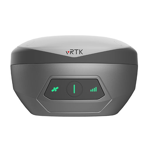
The task adopts the collaborative procedure system of Hi-Target vRTK + UAV to refine 3D models. We applied UAV tilt photography for obtaining images of the roof and elevation, and vRTK for shooting images of the building facade. Afterward, merging the aerotriangulation results, which get from the separate calculation of aerotriangulation, for 3D modeling directly.
The most significant benefit of this solution is that the images taken by vRTK, a GNSS RTK with image positioning technology, contain accurate POS data (RTK level accuracy) in them but also share the same coordinate system, and no need to set connection points or image control points when calculating the aerotriangulation.
This method reduces the workload and makes office work become easier than before.
Workflow
1. Physical Application
1)UAV tilt photography
Applying the five-way tilt photography method when using a Chinese brand UAV for tilt aerial photography.
2) vRTK ground-based close-range photography
Using the vRTK to take close-up photos of building walls that need to be captured in focus as well as surfaces that are hidden by trees.
The firing method is generally to get a façade as the object and carry out the shootings that the neighboring images are overlapped, camera placement with near and far distances, and the view can be tilted. as shown in the following.
In the process, Hi-Target vRTK ground close-range photography for taking additional images must share the same coordinate system, and elevation system with UAV tilt photography. The geoid, China Geodetic Coordinate System 2000, and the China Mobile CORS base station are used in this project. After two hours of operation, the technician completed the physical data set of the two former dwellings.
2. Data processing
The aerial photos collected by the UAV and the close-up photos of the building collected by Hi-Target vRTK are processed by aerotriangulation respectively, and all the aerotriangulation results are combined for 3D modeling in the last stage. A total of two hours is taken to process the whole data.
Result
Through the generated 3D model, it is noticeable that the additional images taken by the vRTK improved the texture of the building facade greatly and supplemented the missing eave members and tree shading missing building facade model by the UAV tilt photography.
In comparison with the 3D model generated from the UAV tilt photography only, the 3D model generated this time can clearly show the detailed structure of the building, and both the architectural elements on the facade, under the eaves and trees, and the cultural elements supporting the building can be finely displayed to meet the needs of the project.
Project Summary
Through the implementation of this project, the following conclusions can be drawn.
(1) Method of applying the Hi-Target vRTK to make up for the ground-based shooting, in conjunction with the UAV photogrammetry, improves the working efficiency greatly. It takes only two hours to complete a total area of 8.07 acres of the two former residence field data collection.
(2) Hi-Target vRTK photos with POS data share the same coordinate system as the UAV aerial photos, enabling internal modeling without using connection points and directly merging the aerotriangulation results for modeling, which simplifies the internal operation process, reduces the workload of the internal industry, and improves the efficiency of the internal processing of taking only 2 hours to complete the refined model building.
(3) The related parameters between UAV and Hi-Target vRTK are close and cause no huge differences in the image resolution, so the modeling fusion is strong, and the generated 3D model is natural and fine.
(4) The ground-based photos taken by Hi-Target vRTK supplemented and improved the local details and textures of the building effectively, and solved the problem of obtaining the textures of the building under the eaves and obscured by trees.


