#Product Trends
Aerial Surveys: A Basic Guide to Drone Imaging
Aerial Surveys
Drone imaging is an innovative technology that transforms methods of aerial surveys. Aside from being safer and speedier, drone imaging offers a more cost-effective method for aerial surveys in military, research, and business industries. By contributing to risk reduction and improved safety, drone imaging provides more efficient aerial surveys for construction, infrastructure assessment, cityscape planning, and environmental screening applications.
MIPAR Image Analysis employs pioneering methods for drone imaging through collaboration with multiple survey companies to guarantee a comprehensive imaging experience. Equipped with specialized automated image analysis and personal consultations, we provide you with a customized software package tailored to every one of your unique user needs. As the technology industry continues to drive forward with emerging innovations, MIPAR stands apart in drone imaging for aerial surveys.
Aerial Surveys with Drones: An Overview
Drone imaging has transformed aerial surveys in various ways. A drone, also dubbed a UAV (unmanned aerial vehicle), can boast superior optical abilities and enhanced manoeuvrability in order to deliver the best survey data and imaging quality possible. With a drone, conducting urban landscape, environmental, and infrastructure aerial surveys are possible in much less time in comparison to traditional field methods.
Drones capture aerial survey data using specialized cameras on the underbelly of the device. The cameras can be customized with distinctive automated image analysis software to extract a particular type of visual information such as thermal measurements or density calculations. This allows for a much more accurate and exhaustive source of information to be available for collection. These photographs offer snapshots of data from various angles, increasing accessibility to locations and material traditionally thought difficult to obtain. Drone imaging, especially when equipped with image analysis capabilities, is thus a powerful technology that efficiently expands the prospective applications of aerial surveys.
Using Automated Image Analysis in Aerial Surveys
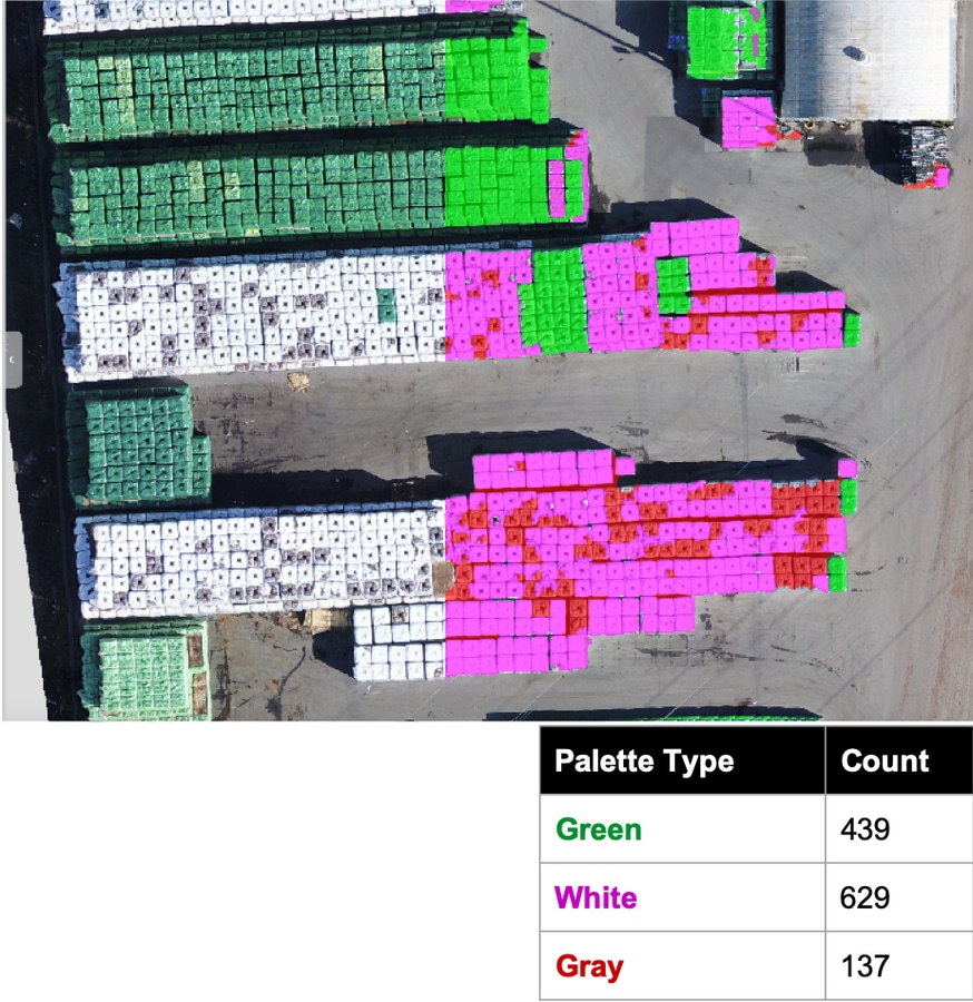
Using automated image analysis in aerial surveys is crucial to extract pertinent information from your data. MIPAR software employs automated image analysis, thus enabling users to easily critically analyze complex visual imagery collected from aerial surveys. Additionally, it can automatically characterize precise focal areas for study, streamlining the analysis process.
The benefits of automated image analysis software are applicable to many purposes, including inspection, remote sensing, manufacturing, and inventory. Examples of automated image analysis application include rapidly making sense of visual data and providing usable statistics based on the collected images. Automated image analysis software packages also enable meticulous inspection of industrial products and can localize small scale defects quickly, often faster than conventional inspection, which reduces the need for time consuming manual intervention.
Ultimately, automated image analysis enhances the information collected by aerial surveys, making it a more meaningful and productive method of data collection for specialized needs.
Aerial Surveys at MIPAR
At MIPAR Image Analysis, we are constantly propelling forward on the frontiers of drone and surveillance innovation with continuous betterment of our device user interface and advanced data processing. Our sophisticated automated image analysis software packages are designed to your personal requirements, including thermal, visible, and nonvisible spectra information processing. We provide simple, uniquely powerful image analysis for you. Contact us today if you would like to know more about our aerial surveys and drone imaging.


