#Product Trends
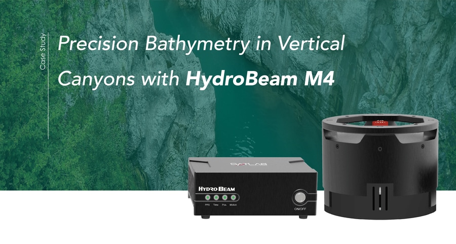
Precision Bathymetry in Vertical Canyons with HydroBeam M4
HydroBeam M4 multibeam echosounder, designed specifically for high-precision hydrographic surveys in complex and vertical underwater terrains.
Project Background
A narrow river winds through a dramatic canyon, its steep, near-vertical rock walls rising sharply on either side. Water depths fluctuate unpredictably—from shallow 1-meter patches to deep 20-meter pools—creating a challenging and dynamic underwater landscape. For the local hydropower plant, having an accurate understanding of this terrain isn’t just a technical task—it is critical for operational safety. Traditional surveying tools struggle to obtain reliable measurements along such near-vertical canyon walls, leaving gaps in the data and increasing risk.
To overcome these challenges, the project team deployed the HydroBeam M4 multibeam echosounder, designed specifically for high-precision hydrographic surveys in complex and vertical underwater terrains.
Challenges Beneath the Surface
Surveying a canyon like this presents multiple obstacles:
Tight confines: some river sections measure less than 20 meters wide.
Vertical walls: extreme slopes create beam distortion and unpredictable acoustic reflections.
Variable depths: rapid transitions between shallow and deep water make consistent measurement difficult.
Acoustic anomalies: multiple reflections between canyon walls, riverbed, and water surface can produce noisy or misleading data.
Deploying the Solution
The project team relied on the HydroBeam M4’s advanced capabilities to tackle these challenges head-on:
150° swath coverage for extended side-wall data acquisition
1024 beams providing dense, high-resolution bathymetric point clouds
Vertical Terrain Algorithm ensures stable measurements on steep slopes and vertical walls.
Integrated GNSS, IMU, and SVS simplify installation and allow precise positioning and motion compensation
Data Acquisition Workflow
1.Survey Line Planning
Parallel survey lines with ≥30% overlap to ensure full coverage
Calibration measurements gathered at key terrain spots
2.Field Survey
Small manned survey vessel equipped with HydroBeam M4
Sound velocity profiles measured in multiple locations to correct for sound propagation variations
3.Real-Time Acquisition
HydroBeam Monitor software automatically adjusts system parameters to ensure stable data.
SLHydro Survey software collects the data and provides real-time visualization.
Data Processing
Software: SLHydro Survey used for post-processing
Data Integration: GNSS, IMU, and multibeam measurements merged with calibration parameters
Noise Filtering: Removal of anomalous or erroneous depth points
Output: High-resolution 3D underwater point clouds, contour maps, and cross-sectional profiles suitable for engineering analysis.
The canyon survey proves that HydroBeam M4 is a game-changing solution for challenging vertical terrains. Delivering full-coverage, high-resolution bathymetry with reliability and precision, it empowers engineers and operators to make confident decisions while setting a new standard in hydrographic surveying.
Project Outcome
The HydroBeam M4 multibeam echosounder successfully transformed a complex vertical canyon survey into a precise, efficient, and reliable operation. Beyond delivering high-resolution, full-coverage bathymetry, it empowers engineers and hydropower operators to make informed decisions with confidence, redefining standards for hydrographic surveying in challenging environments.