
#Industry News
CCTV Xinwen Lianbo Features SpatiX,QYX Pro Gains Recognition from Turkish Users
On July 31, marking the sixth anniversary of the BeiDou-3 Global Navigation Satellite System, CCTV News and Xinwen Lianbo, China’s flagship evening news program, featured reports on SpatiX’s BeiDou-powered agricultural machinery navigation system and
On July 31, marking the sixth anniversary of the BeiDou-3 Global Navigation Satellite System, CCTV News and Xinwen Lianbo, China’s flagship evening news program, featured reports on SpatiX’s BeiDou-powered agricultural machinery navigation system and its applications in global markets.
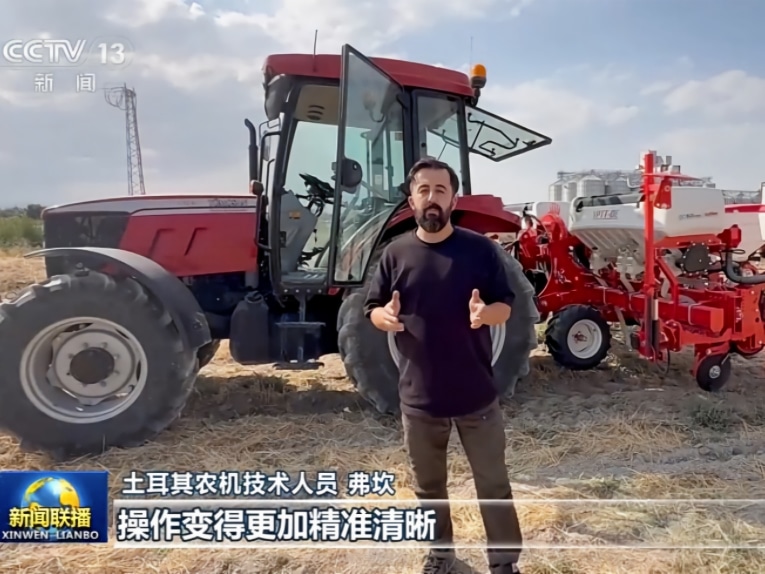
The report followed Gao Wei, an agricultural machinery engineer from SpatiX, during field operations in Konya, Türkiye, documenting the installation and testing of the system for local farmers. In the report, Furkan, an agricultural machinery technician in Konya, shared his experience:
“With the navigation system, operations have become more precise and easier to manage. Planting rows are more consistent, and production efficiency has improved significantly. For farmers, it is a very practical and user-friendly system.”
Feedback from overseas users highlights the practical value of SpatiX’s BeiDou-based spatiotemporal intelligence technology in modern agricultural production.
From Experience-Driven Farming to Precision Agriculture: Four Key Improvements for Turkish Farmers
Konya, where Furkan is based, is one of Türkiye’s major agricultural regions. Traditionally, farming operations relied heavily on operators’ experience, with activities such as sowing, plowing, and harvesting affected by weather conditions, lighting environments, and manual operation accuracy.
SpatiX’s BeiDou agricultural machinery navigation system is helping transform this traditional approach by bringing greater precision and automation to farming operations.
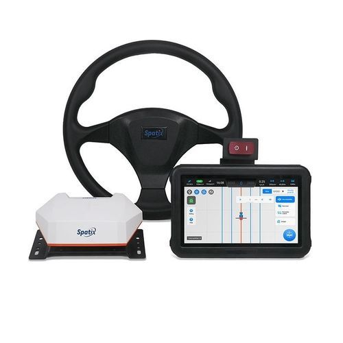
Powered by high-precision positioning services based on the BeiDou satellite system, combined with in-vehicle intelligent terminals, receivers, and sensors, the system can accurately determine the real-time location of agricultural machinery in the field. An automated steering system enables machinery to follow predefined routes with high precision.
After adopting the navigation system, farmers have experienced four major improvements:
First, reduced workload and lower skill requirements.
Traditional agricultural machinery operation requires drivers to manually control steering throughout the process, demanding significant experience and concentration. With the navigation system, machinery can automatically maintain straight-line operation, reducing operator workload. Farmers can quickly master the system after short-term training, helping lower labor costs.
Second, greater flexibility in farming operations.
Previously, agricultural operations were often restricted by lighting conditions and visibility. With high-precision positioning capabilities, tractors can operate more effectively in different environments and extend available working hours during critical farming seasons.
Third, improved operational accuracy and land utilization.
Traditional farming relied on visual judgment and experience, which could lead to accumulated deviations over long distances. The navigation system automatically adjusts routes, maintains accurate straight-line operation, and ensures consistent row spacing, helping reduce land waste and improve efficiency.
Fourth, fewer overlaps and missed areas.
During turning operations and field transitions, the system helps machinery seamlessly connect to the next operation path, avoiding repeated work or missed sections and improving overall operational quality.
From experience-driven farming to data-driven agriculture, SpatiX’s BeiDou agricultural machinery navigation system is helping farmers worldwide move toward smarter and more efficient agricultural production.
Satellite-Ground Integration and ISOBUS Certification: Building End-to-End Capabilities for Precision Agriculture
Behind these precision agriculture applications is SpatiX’s end-to-end capability, covering positioning services, intelligent terminals, and agricultural machinery solutions.
Facing diverse agricultural environments around the world, SpatiX leverages its satellite-ground integrated positioning infrastructure, combining satellite-based augmentation services with ground-based enhancement networks. This enables agricultural machinery to achieve centimeter-level positioning even in areas with limited or weak network connectivity, supporting reliable operations in various scenarios.
Beyond standalone machine intelligence, SpatiX is also enabling more seamless collaboration between navigation systems and different types of agricultural equipment, improving operational efficiency and reducing costs.
The SpatiX QYX Pro agricultural navigation system has completed comprehensive testing against the ISOBUS standards established by the Agricultural Industry Electronics Foundation (AEF), an internationally recognized industry organization, and has obtained certification across multiple functional modules, including UT (Universal Terminal), AUX-N (Auxiliary Control), TC-BAS (Task Controller Basic), TC-SC (Section Control), and TC-GEO (Geo-based Variable Rate Control).
ISOBUS is a globally recognized communication standard in the agricultural machinery industry. It enables tractors, seeders, sprayers, harvesters, and other agricultural equipment from different manufacturers to exchange data and work together seamlessly.
This certification demonstrates SpatiX’s ability to support integrated agricultural operations, allowing farmers to manage multiple machines through a unified interface. Intelligent functions such as section control and variable-rate application further optimize the use of inputs including fertilizers and pesticides, improving resource efficiency and supporting the transition from experience-based farming to data-driven agricultural management.
SpatiX Brings BeiDou-Powered Spatiotemporal Intelligence to Global Agriculture
The application of SpatiX’s technology in Turkish farmland represents a significant milestone in the company’s global expansion.
To date, SpatiX’s spatiotemporal intelligence services have expanded across multiple countries and regions in Europe, Asia, and South America. The company has built more than 10,000 BeiDou satellite-based and ground-based augmentation stations worldwide, serving more than 2.7 billion users cumulatively.
According to Chen Jinpei, CEO of SpatiX, the global adoption of BeiDou-based spatiotemporal intelligence is supported by three integrated capabilities: satellite-ground integration, cloud-chip integration, and software-hardware integration. These capabilities represent SpatiX’s long-term investment in positioning infrastructure, core services, key components, and foundational software, enabling spatiotemporal intelligence technologies to scale across industries worldwide.
As industries such as engineering equipment, intelligent vehicles, and smart agriculture continue to expand globally, SpatiX is bringing advanced spatiotemporal intelligence solutions to more countries and regions, contributing Chinese technological expertise to the digital transformation of global industries.
About SpatiX
SpatiX is the global leader of spatiotemporal intelligence founded in 2015, with Alibaba being our largest shareholder. At present, our valuation exceeds USD 2.2 billion. Based on worldwide groundbased and satellitebased augmentation system, we have provided highprecision positioning services to 2.7 billion devices all over the world, and empowered customers in all industries, including geospatial, agriculture, construction, autodriving, drones, embodied intelligence etc.